Valid: 03-Jul-2026 10:00am
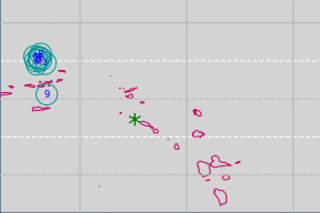
Statia is at the green asterisk in the map.
| # | local time | latitude | longitude | magnitude | depth | place |
|---|---|---|---|---|---|---|
| 1 | 2-Jul 12:18am | 19°34′45″N | 64°34′30″W | 4.0 | 38km | 140 km N of Cruz Bay, U.S. Virgin Islands |
| 2 | 1-Jul 2:46am | 19°33′23″N | 64°24′43″W | 3.4 | 55km | 141 km NNE of Cruz Bay, U.S. Virgin Islands |
| 3 | 29-Jun 9:03pm | 19°34′23″N | 64°23′22″W | 3.7 | 25km | 143 km NNE of Cruz Bay, U.S. Virgin Islands |
| 4 | 29-Jun 6:31am | 19°36′4″N | 64°29′50″W | 3.9 | 36km | 143 km NNE of Cruz Bay, U.S. Virgin Islands |
| 5 | 28-Jun 8:09am | 18°25′30″N | 64°11′8″W | 3.4 | 25km | 65 km E of Cruz Bay, U.S. Virgin Islands |
| 6 | 28-Jun 1:58am | 19°38′7″N | 63°46′9″W | 3.8 | 15km | 173 km NNW of The Valley, Anguilla |
| 7 | 27-Jun 10:06pm | 19°39′48″N | 63°30′15″W | 4.1 | 59km | 166 km NNW of The Valley, Anguilla |
| 8 | 27-Jun 1:22pm | 17°53′43″N | 63°56′53″W | 3.4 | 16km | 79 km WNW of The Bottom, Bonaire, Saint Eustatius and Saba |
| 9 | 25-Jun 10:52pm | 18°53′2″N | 64°48′50″W | 3.4 | 16km | 61 km N of Cruz Bay, U.S. Virgin Islands |
| 10 | 25-Jun 7:35pm | 19°40′36″N | 63°39′38″W | 4.0 | 19km | 173 km NNW of The Valley, Anguilla |
This weather information is derived from usually reliable government and private sources but it is not an official government product. Monitor your local radio station for storm watches and warnings issued by local authorities. We do our best to provide accurate information as a free public service, but we assume no liability for errors.